Montpelier Row Twickenham – Georgian Architecture at its best!

Twickenham has been the much loved home to many writers over the centuries; Alexander Pope, R C Sheriff, Horace Walpole, Elizabeth Twining, Walter De La Mare and Alfred Lord Tennyson. On the banks of the River Thames this once quiet, village location has been swallowed up into the metropolis of Greater London, but still retains some of its charm. While many of the beautiful riverside mansions of the 18th and 19th centuries have long since been demolished, there is one perfect row of Georgian homes which have remained.
Both Alfred Lord Tennyson and Walter De La mare lived at some point in this row. Walter De La Mare moved into Southend House in 1940 and became a tenant of the Sedgwick Family. Although he spent much of the war time years away from the house, he loved the house and kept his collection of antiques here, as well as his books on crime. Many of his closest friends and literary friends came to visit him here including Joyce Grenfell, Leonard Clark and Richard Church. De La Mare died at Southend on 22 June 1956.[1]
Tennyson moved into Chapel House on Montpelier Row in 1851 and stayed there with his wife until 1853. This was at the time that he had been made Poet Laureate. His son Hallam was born at Chapel House and baptised in the local St Mary’s Church. However, Tennyson soon found that Twickenham was too close to the ever expanding London. The railway had recently arrived in Richmond and Twickenham and with it brought a ;large number of visitors. Although he cherished his visits from his fellow literary friends, W M Thackeray and Edward Fitzgerald he decided to leave Montpelier Row and leave it to his widowed mother, Elizabeth Tennyson while he moved to the Isle of Wight.
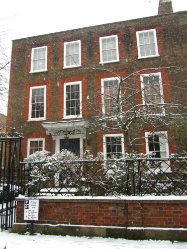
Over the years Chapel house became known by other names including Holyrood House and now it is simply number 15. When first built it was also listed as number 17, and appears to have changed to 16 sometime around the mid nineteenth century and certainly by 1871 when Captain Phillip Antrobus lived there from 1871 with his wife and children.
Yet Tennyson is not the lonely famous artist to have lived there. Peter Townsend of the band, The Who, lived in the property for a number of years, and his wife continued to live there after their divorce from 1987 to 2004, converting the coach house at the end of the garden into a recording studio.
Montpelier Row, which borders Marble Hill Park was built in 1723 by Captain John Gray. It is situated in East Twickenham, off the Richmond Road and runs alongside the western boundary of Marble Hill Park. Halfway down is Chapel Road which connects with Orleans Road and this is the site of the old Montpelier Chapel which was demolished in the 1940’s. Number 15 is on the corner of Montpelier Row and Chapel Road. The property is Grade II listed and it has a blue plaque for Alfred Lord Tennyson. The properties were built around 1720-1721 and a plague on number one states ‘Montpelier Row’ 1720. Gray moved into the Row soon after it was built, and appears to have had a number of financial difficulties. Many of the properties wouldn’t sell or could be let and as a result many of the builders initially lived in the beautiful Georgian town houses. Gray in fact continued to live in the row until his death in 1751 and in 1748, was living at number 14.
Chapel House/Holyrood House is a three storey Georgia townhouse with a basement and also has a separate two storey building in the garden. Many of the houses in the street are of similar structure although the mid terraced ones tend to be single fronted. As Chapel House stands at the end it would most likely have reflected North end House which stood at the far end where the entrance from Richmond Road is now, and which was demolished some years ago. As is customary these days, many of the houses have also extended upwards into the loft spaces.
Prior to the development by Gray, the whole area of land which ran along the riverside was a part of Eastfield, a name derivative from the medieval period where the area of Twickenham was divided into Eastfield, Westfield, Southfield and Northfield. Moses Glover’s Map of 1635 lists the area has arable with neighbouring M. Craftons Nursery and orchard.[2] Also in the locality are the Butts which were targets for archery practice and was situated at the edge of East Field and the village, where Montpelier Row feeds of which is now Richmond Road. Captain Gray became a prominent landowner in Twickenham in the early eighteenth century. Following the end of his service in 1713 he received a substantial payout which helped him to become a property developer and he leased two plots of land from the Sion Estate, owned by the Duke of Northumberland.
Gray’s concept was urban in style and copied the prestigious homes of the new London squares. This was a departure from the local style where there were several grand estates, but also large detached properties which stood in their own land along the riverside in Twickenham. It was the first local urban terrace and they were built to be leased, a speculation perhaps in response to the growth of Twickenham due to agriculture and commercial gardens.[3] But also to the popularity of the riverside area and the lure of the Thames for the upper classes and when Horace Walpole died here in 1797, large houses and immaculate gardens lined the riverside stretch from Cross Deep to Richmond, incorporating Montpelier Row.
This new style might have surprised the locals and be seen as an intrusion on the style of Twickenham. The other Queen Anne and early Georgian properties adopted a more classical style, which had been made popular by Inigo Jones in the seventeenth century.
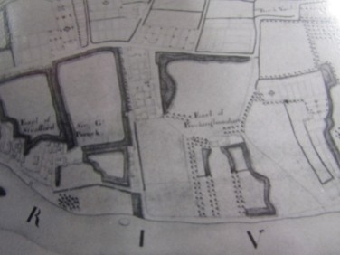
Montpelier Row was built on its own, away from the centre of Twickenham which may suggest the clientele that Gray was trying to attract. They remained for some time as the only properties in the area of what is now East Twickenham. The map below shows Montpelier Row and the surrounding area in 1741. We can see that surrounding the property were gardens and open space, and Orleans Road was at this time called Folly Lane. Although its neighbouring Marble Hill House is indicated, it is not listed until the later map of 1786.
[4] and [5]

The enclosure plans of 1819 show the detail of the properties in much greater depth and also include the chapel which is not shown specifically on earlier maps. The next map shows the area in 1846, and we can see that a number of properties have been built on the land surrounding Montpelier Row, although the area off of Orleans Road or Folly Lane is still gardens. However, this indicates that the area is beginning to develop further and where Montpelier was once rural, the area was becoming increasingly suburban which may link with the establishment of the railway in Twickenham in 1848. [7]

The image above shows Montpelier Row to the left of Marble Hill Park in 1749 and this clearly shows, that the properties stood alone at this time, surrounded by land.[8]

The illustration below is taken from a lithograph by Thomas Way in 1900 and shows extension already made to the upper floors of several properties.

A number of people have lived in this house over the years, most of which were not notable writers and artists. Details of the occupiers can be found in the Poor rates records, census returns from 1841-1911, local directories and electoral rolls all of which can be found in the Richmond Local Studies Library.
There is no question that Montpelier Row is one of the finest surviving examples of Georgian architecture in London. Nearby Sion Road, which runs down to the River Thames was built at the same time, and although is a much shorter row, is as beautiful as Montpelier and well worth a look if you are in Twickenham.
Montpelier Row was no doubt the home of poems, prose and pop songs and fine Georgian houses.
Bibliography and Notes
[1] Twickenham Museum Website , http://www.twickenham-museum.org.uk/detail.php?aid=26&ctid=1&cid=7, Wlater De La Mare.
[2] Simpson, D., Twickenham Past (Historical Publications: London 1993) pp16-17
[3] Simpson, D., Twickenham Past (Historical Publications: London 1993) pp116-118
[4] Map of Richmond 1741-45 by John Rocque.
[5] Map of the Manor of Isleworth and Sion 1786. Duke of Northumberland. Surveyed and draw by C J Sauthier. This is a photo of the section surrounding Montpelier Row, Marble Hill and the local area.
[6] Enclosure Wards Plans 1819, held at the Richmond Local Studies Library.
[7] Warrens Plan of the Parish of Twickenham 1846, held at the Richmond Local Studies Library.
[8] Gascoigne, B & Ditchburn J., Images of Twickenham, (Saint Helena Press: Richmond, 1981)
[9] Gascoigne, B & Ditchburn J., Images of Twickenham, (Saint Helena Press: Richmond, 1981)
[10] Gascoigne, B & Ditchburn J., Images of Twickenham, (Saint Helena Press: Richmond, 1981)


